Advances in analytical methods, remote sensing, and particularly machine learning (ML) are transforming how historical geoscientific datasets are leveraged in exploration. Information once constrained by legacy instrumentation and limited computation can now be reexamined with far greater sensitivity and complexity to guide targeting. This progress is especially relevant to publicly funded and systematically collected geochemical surveys designed to support discovery across the sector, as data from these precompetitive programs offers broad coverage and consistent quality yet remains largely underutilized.
Investigating how such datasets can be reinterpreted forms the basis of a doctoral research project by Matthew Bodnar, Senior Geologist at VRIFY and PhD candidate at Queen’s University. The work treats northwestern Manitoba’s legacy lake-sediment archive as a testbed for applying ML in tandem with Quaternary surface reconstructions to extract new exploration value from regional geochemistry. Its broader objective is to establish workflows that combine sample reanalysis with surface landscape knowledge to produce public prospectivity products that can help stimulate investment and advance critical mineral exploration.
Leading the Work
Matthew studied geological sciences at the University of Manitoba before completing a master’s in exploration geochemistry at the University of British Columbia. Since then, he has worked in both corporate exploration and consulting, roles that grounded him in field practice and data interpretation while also exposing him to the pressures and priorities of real-world exploration decision-making. Where many in industry migrate into management roles after a decade of experience, he chose to pursue a PhD at Queen’s University in May 2025 to deepen his technical expertise.1,2 This decision reflects the balance he aims to strike in his work: scientific rigor aligned with the pragmatic realities of exploration programming.
The Dataset
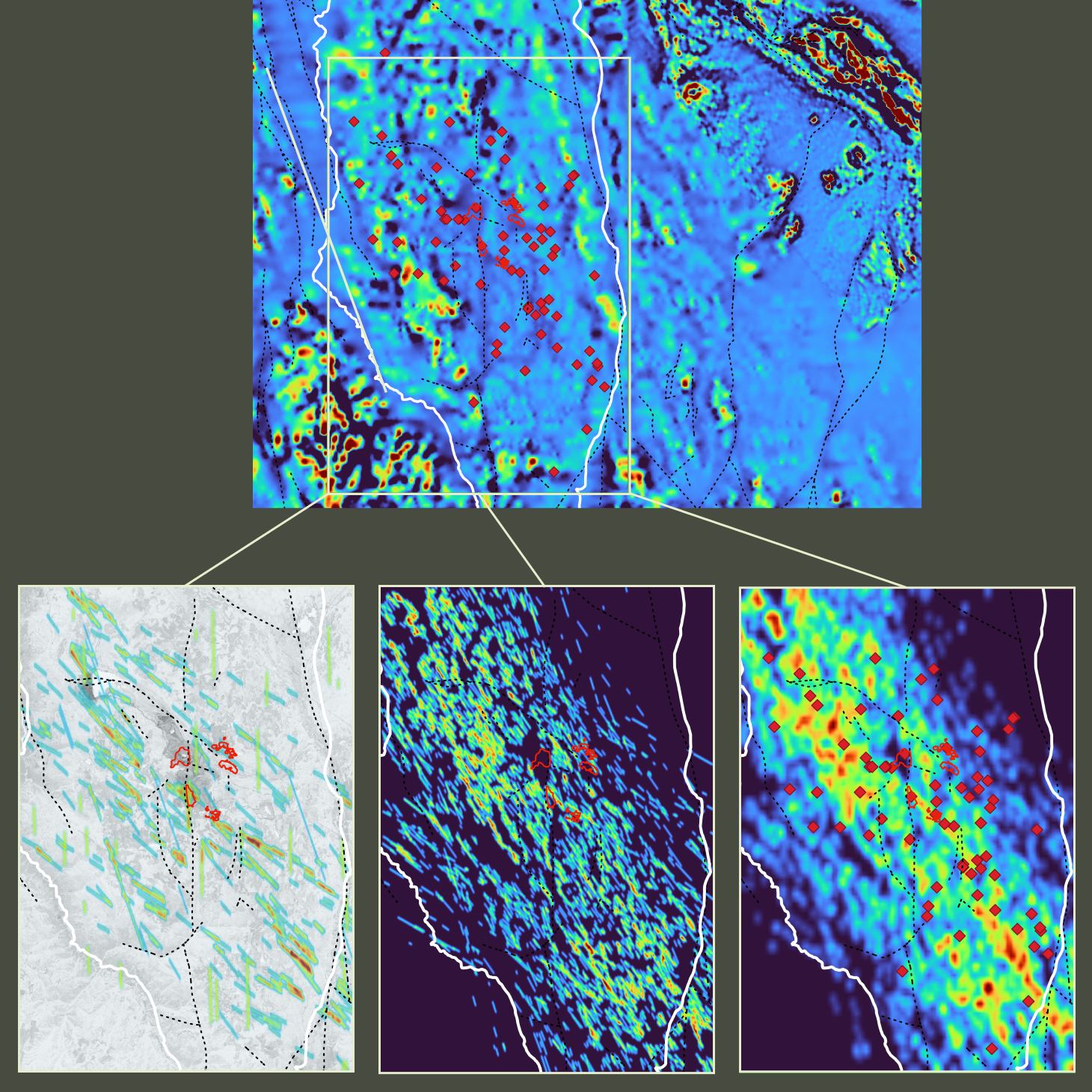
The study revisits a set of lake-sediment surveys from the mid-1970s and mid-1980s, covering roughly 52,000 square kilometres across four 1:250,000 scale National Topographic System (NTS) map sheets in northwestern Manitoba. These helicopter-supported sampling programs accessed remote lakes and collected fine silt and clay from the lake bottom at a density of one site per 13 square kilometres. The original analyses relied on atomic absorption spectroscopy and a narrow element suite. In 2022 and 2023, the Geological Survey of Canada reanalyzed the archived material by inductively coupled plasma mass spectrometry, producing a modern multielement dataset with lower detection limits and higher analytical resolution.
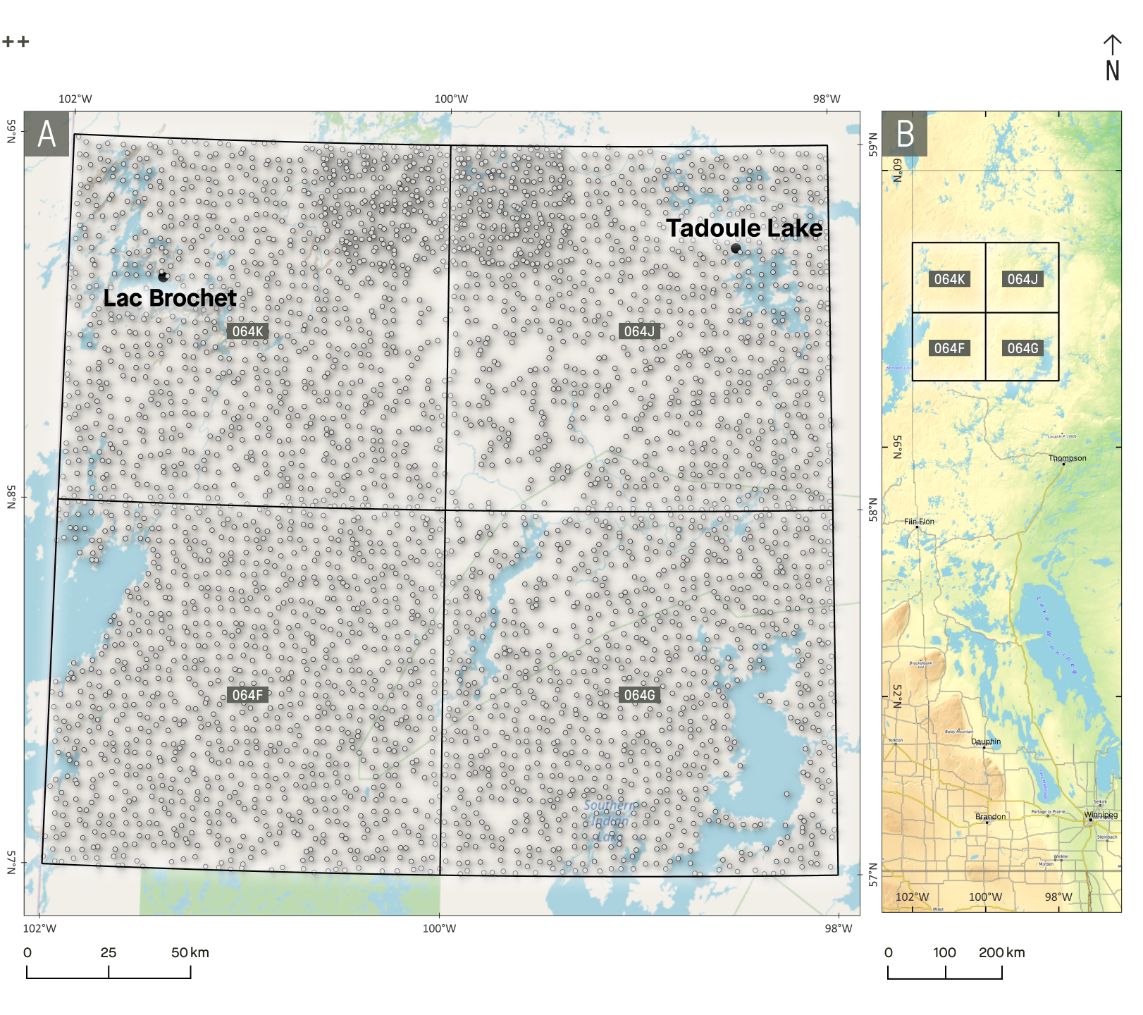
Why Surface History Matters
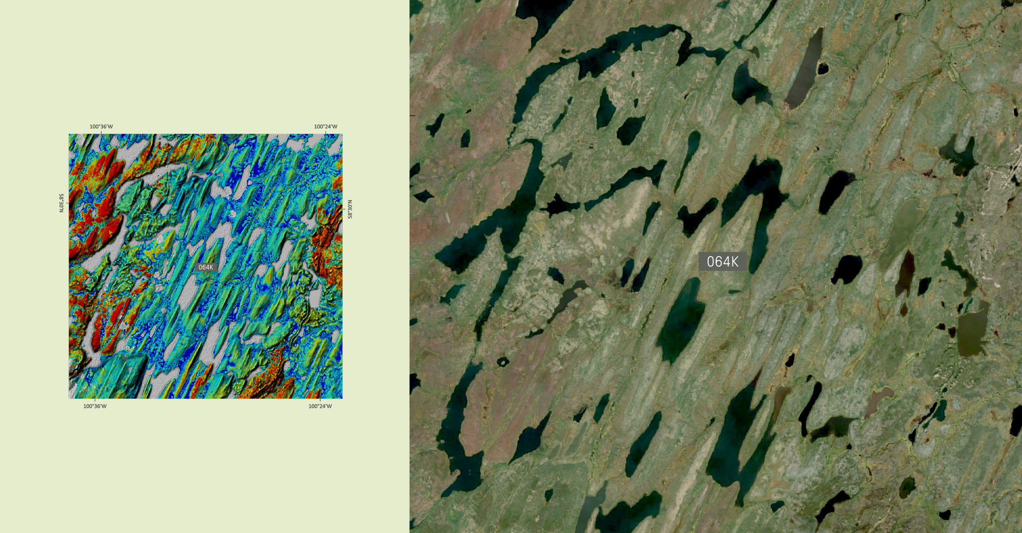
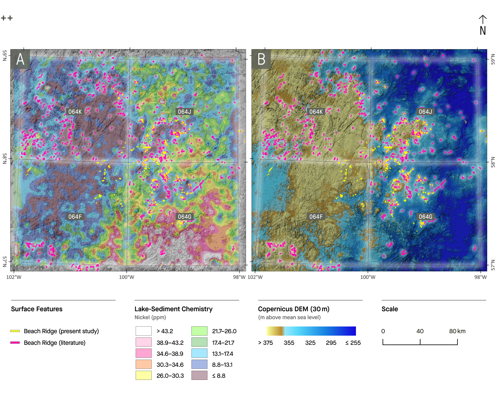
Lake sediments do not record the chemical signal of bedrock in isolation. They carry the imprint of Quaternary glaciation, from the scouring of advancing ice to the inundation by proglacial lakes and the reworking of sediments that followed the ultimate glacial retreat. Early examination of the data reveals that the concentration of some elements, such as nickel, shifts systematically between paleolake basins and ground that remained above meltwater limits. Without acknowledging this overprint, ML models designed to identify patterns linked to mineralization may instead unintentionally rank surface history. To address this, Quaternary context may be embedded directly in the methodology.
How the Study Approaches the Problem
(1) Reconstructing Surface History
Remote-sensing imagery and digital elevation models (DEMs) are used to rebuild the surface history of the region, capturing the imprint of glacial and meltwater features. This framework allows for interpretation of geochemical patterns in the context of erosional and depositional processes.

(2) Modelling with Geological Conditioning
The chemistry is explored to determine how samples group together and what these patterns reveal. Predictive models are then trained to highlight areas of higher prospectivity, with variables tied to glacial history — such as ice-flow direction and paleolake extent — included as conditioning inputs. This helps separate true bedrock signals from surface overprints. Interpretability is integral to the process: SHAP (Shapley Additive Explanations) values are used to show which factors are driving predictions, ensuring that each target rests on a clear geological context.
(3) Validation and Delivery of Outputs
Models are tested for consistency and benchmarked against known mineral occurrences. With these checks in place, the results are delivered as prospectivity grids supported by transparent geological rationale and GIS-ready layers that can be integrated seamlessly into exploration workflows.
What This Means for Explorers
The benefit is not only academic. Conditioning geochemistry on surface history reduces false positives where transport dominates and helps preserve real anomalies where bedrock control survives. This improves the odds that ranked targets reflect local bedrock geology rather than surficial processes. The approach also makes collaboration between geologists and data scientists more visible and concrete, as the contribution of each input can be shown and discussed rather than left as a black box, helping eliminate a major cause of skepticism toward ML outputs in exploration practice.
Although the case study uses a legacy sample set, the data and approach are not tied to the past. The same principles apply to new surveys in glaciated regions and, with suitable adjustments, to stream-sediment or soil surveys in other terrains, offering a clarity for linking regional geochemistry to mineral prospectivity.
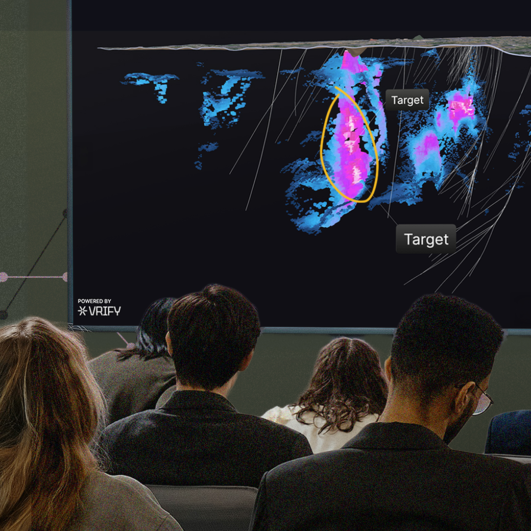
This research aligns with the methodology underlying DORA, VRIFY’s AI software that generates geologically explainable targets from multivariate datasets using ML models. By testing comparable methods on a well-documented regional dataset, Matthew’s study offers insight into how predictive models can capture geological controls on mineralization more accurately and translate these relationships into practical prospectivity outcomes.
<hr/>

.png)


.jpg)
.png)