Project Background
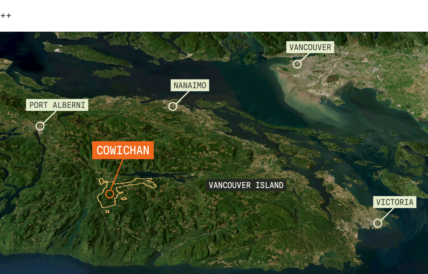
Cowichan is an early-stage gold and copper exploration project, taking its name from the valley where it sits on Southern Vancouver Island, British Columbia. The project is being advanced independently by economic geologist and mining entrepreneur Darcy Vis, B.Sc., P.Geo., with support from his team at Tripoint Geological Services.
Southern Vancouver Island has long been disregarded for mineral exploration, in part because of the operational complications that come with working in close proximity to Victoria, a major urban centre. This view is beginning to change, and with it, there is a realization that significant potential may have been overlooked. This region of the island hosts Jurassic arc-related rocks, including the Bonanza Group volcanic and volcaniclastic rocks and related intrusions. The combination of permeable and reactive volcanic packages with hydrous metal-laden intrusions represents a classic setting for porphyry-epithermal copper–gold mineralization. Elsewhere in British Columbia, similar rocks contain significant mineral deposits, most notably along the northern extension of the Bonanza arc, which hosts the North Island mining district, as well as in the Hazelton Group of the Stikine Terrane across the province’s northwestern and central regions.
For the Cowichan Valley specifically, the historical record offers reason to pay closer attention to its mineral potential. Assessment reports from Gold Dyke, a known occurrence in the area, documented a grey porphyritic volcanic unit with localized bleaching and alteration, while noting quartz-carbonate veining and mineralization that included gold, silver, lead, and zinc. Other targets identified in the vicinity, including Archer and Jasper, indicated a mineralizing system that may extend well beyond a single showing. For Darcy, this evidence was enough to stake the ground and begin exploration across the land position.
This use case highlights how Darcy applied DORA, VRIFY’s AI prospectivity mapping software, to test exploration hypotheses and refine targets across the Cowichan property.
The Why
Darcy’s decision to try DORA was driven primarily by curiosity. He had been keen to understand whether AI prospectivity modelling could add genuine value to mineral exploration. Cowichan offered a practical setting for that test, with familiar geology and information that was not extensive, but sufficient to work with.
There was also a practical dimension. Conventional exploration had already identified several targets and led to theories about additional areas of interest, but evaluating the full claim block with the same level of consistency was difficult to achieve using traditional means. DORA offered a way to review the property as a whole within a single integrated framework, creating an opportunity to pressure-test the exploration thesis and surface any prospective areas that earlier work may have missed.
The Process
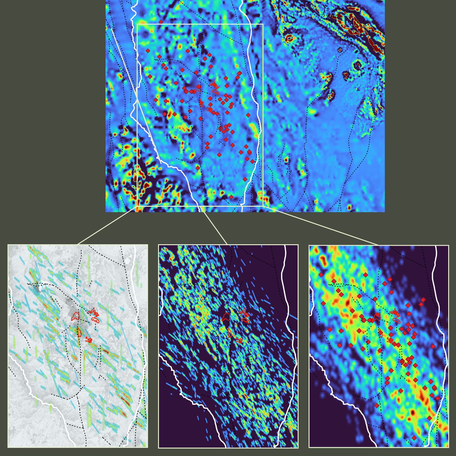
To establish a broader analytical foundation across the land position, the VRIFY team helped to combine the proprietary Cowichan dataset with regional public-domain data covering geophysics, geology, and geochemistry.
The resulting dataset was then enhanced before undergoing augmentation through several of DORA’s Data Augmentation Modules, including Lineament Maps and Distance Maps. These steps improved consistency and comparability while strengthening structural interpretation and spatial context.
From that point on, Darcy ran modelling experiments in DORA without further guidance from the VRIFY team. Three Foundation Models were used to test deposit concepts considered relevant to Cowichan’s geology. The epithermal model, which aligned with the primary working hypothesis, focused on near-surface gold and silver mineralization. The porphyry model assessed deeper, larger-scale gold and copper potential. Given the presence of volcanic rocks in the region, the volcanogenic massive sulphide (VMS) model was also applied.
In addition, Darcy ran a Deposit-Agnostic Model, designed to evaluate mineralization potential without the refinements of any specific deposit type. Across all experiments, feature-importance values, a key output of DORA, indicated how strongly individual inputs influenced prospectivity and target ranking, helping clarify what was driving each result.
The Outcome
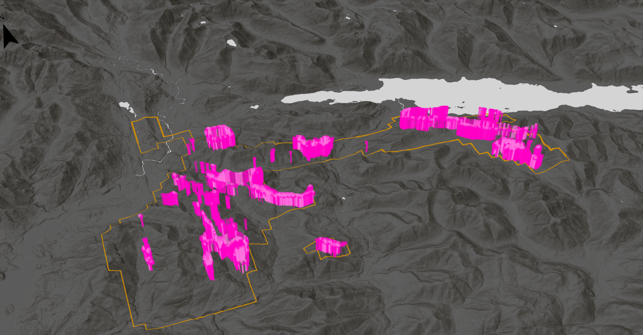
Prospectivity outputs from DORA, expressing mineralization probability, largely confirmed both the existing targets and theorized areas at Cowichan. The modelling also flagged an additional area with a high VRIFY Prospectivity Score (VPS), indicating strong mineral potential, in a location Darcy would not otherwise have considered exploring. This area was subsequently named the AI 3000 Zone.
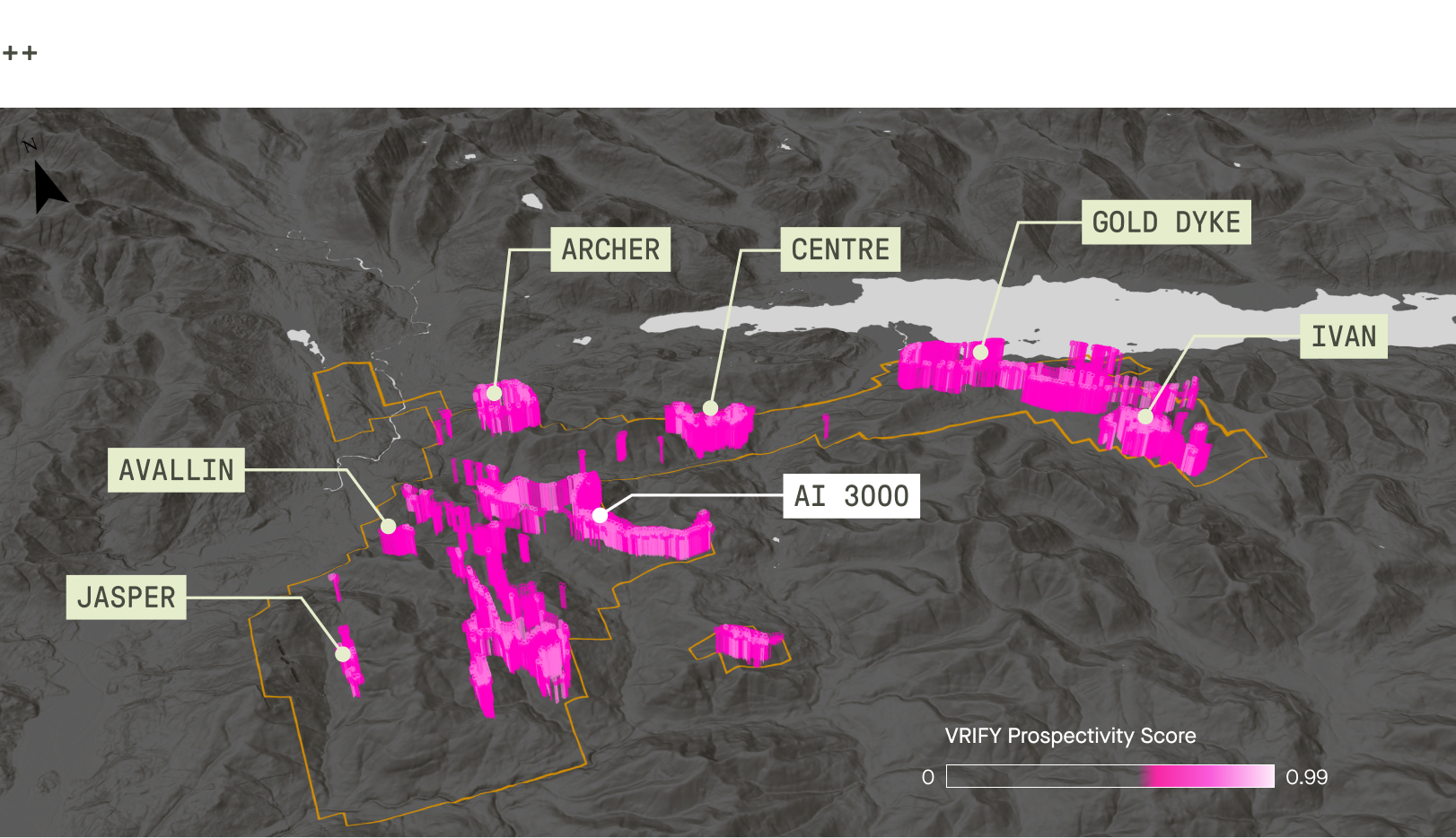
Acting on this insight, Darcy dispatched his team to investigate. Structural trends extracted through the Lineament Maps Module, which had already refined understanding of the property earlier in the process, also helped direct the fieldwork by providing a clearer picture of what to observe and measure on the ground.
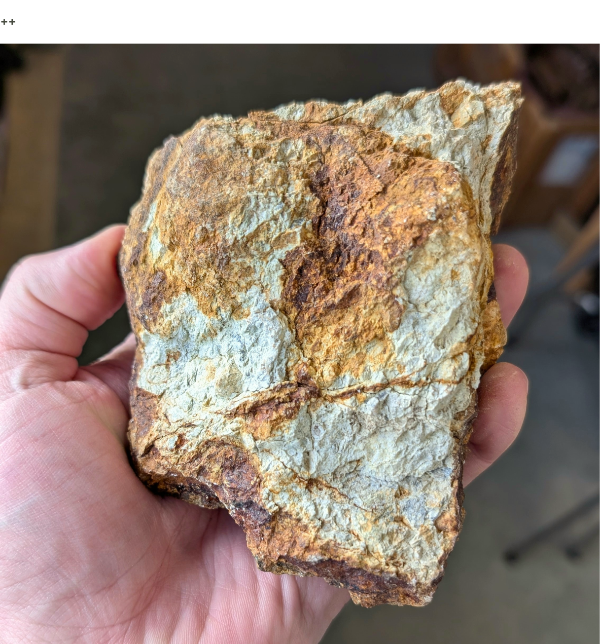
Prospecting identified a heavily clay-illite altered volcaniclastic tuff, closely resembling alteration observed at the known mineralized zone Gold Dyke. The presence of jarosite and goethite, together with hydrothermal clays such as kaolinite and montmorillonite, in the rock pointed to a possible argillic alteration zone associated with an epithermal environment. Alteration assemblages of this type are significant because they are indicative of the potential to host mineralized veins. While this “shiny” rock is not definitive proof of mineralization, it suggests that the AI 3000 Zone may contain a hydrothermal system capable of concentrating metals. This makes the zone an ideal target for utilizing the successful exploration methodologies refined at the Gold Dyke Zone, including geological mapping, geochemical sampling, and geophysical surveys.
Among the three deposit-specific models tested, the VMS model returned the weakest prospectivity signals, consistent with Darcy’s long-held skepticism about whether the Cowichan area hosts a conventional VMS system. In his view, the historical interpretation had been unduly shaped by the influence of Myra Falls, a nearby polymetallic VMS mine. The modelling appeared to support that assessment, helping narrow the range of plausible models for the property.
The Deposit-Agnostic Model surfaced further areas of high potential beyond the AI 3000 Zone, expanding the target set for future exploration. What began as curiosity about a new technology had, by the end, proven its worth, giving Darcy a more focused exploration program and greater confidence to continue investing in the project.
When asked about his experience working alongside an AI tool as an experienced geologist with his own established targets and theories, Darcy Vis, President and co-founder of Tripoint Geological Services, said the following:
"I would say I, along with most geologists, am open to innovation and theory testing, but we are skeptical of new technologies. To really have buy-in, we have to see that AI and machine learning tools work, can positively identify known zones, and have some scientific backing. I personally think machine learning, if done well, has significant benefits and I understand just enough about it to see its value. I think that its use as a marketing tool early on in its development really hurt its reputation with scientists, but that is rapidly changing as we get improved systems like VRIFY’s DORA, and we see the measurable benefits."
<hr />
To learn more about DORA and VRIFY’s broader suite of tools for exploration analysis and effective communication with stakeholders, book a demo with our Geoscience Team.

.png)


.jpg)
.png)